![]()
|
|
|
Home
|
2001 Chad Antelope Survey 1 SAHELO-SAHARAN ANTELOPE SURVEY IN CHAD An Interim Report September 5th through October 5th, 2001 CHAD WILDLIFE SURVEY TEAM: Steven
L. Monfort, DVM, PhD Smithsonian
Institution, USA MAJOR
FISCAL SPONSORS: OTHER CONTRIBUTORS Brookfield
Zoo, Disney’s Animal Kingdom, Oregon Wildlife Foundation, Peace River Refuge,
San Antonio Zoo, BACKGROUND AND SCIENTIFIC JUSTIFICATION FOR THE PROJECT A century ago, hundreds of thousands of antelopes and gazelles roamed the Sahara and Sahel regions of Africa, a vast area of desert and sub-desert ecosystems encompassing significant parts of the following countries: Algeria, Chad, Egypt, Libya, Mali, Mauritania, Morocco, Niger, Sudan, and Tunisia. Endemic species such as scimitar-horned oryx (Oryx dammah), addax (Addax nasomaculatus), dama gazelle (Gazella dama), slender-horned gazelle (G. leptoceros), and Cuvier’s gazelle (G. cuvieri) are exquisitely adapted for survival in extremely harsh desert ecosystems (Newby, 1984).
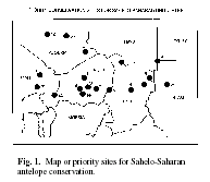
Fig. 1. Map or priority sites for Sahelo-Saharan antelope conservation. Over-hunting, aided by the spread of modern weaponry, all-terrain vehicle use, war and civil strife, and inadequate budgets and infrastructure to enforce conservation legislation, have contributed to the steady decline of Sahelo-Saharan wildlife. Changing human land and resource use patterns, coupled with repeated droughts and man-made desertification, have further pushed most species to the brink of extinction (Newby, 1978, 1980, 1981, 1984, 1988). Although recent detailed information on the conservation status of Sahelo-Saharan species is lacking for most countries, Chad and Niger have been identified as priority sites for the conservation of Sahelo-Saharan antelope (Newby, 1998, see map, above and Table 1below), and both countries are top-ranked in terms of the reported presence of larger aridlands mammals. Furthermore, 8 of 14 of the priority sites for Sahelo-Saharan antelope are in Niger
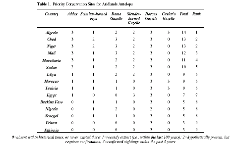
Table 1. Priority Conservation Sites for Aridlands Antelope 0=absent within historical times, or never existed there; 1=recently extinct (i.e., within the last 100 years); 2=hypothetically present, but requires confirmation; 3=confirmed sightings within the past 3 years
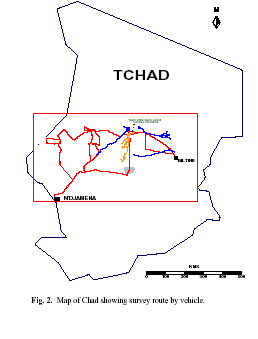
Fig. 2. Map of Chad showing survey route by vehicle. (Aïr/Ténéré, Termit, Gadafawa, Tadress, and Gadabeji) and Chad (Wadi Rimé/Wadi Achim, Mourdi, and Kanem). Because no systematic surveys of these areas have been conducted in the past two decades, new surveys were needed to determine the status of remaining wildlife and to assess the options and potential for in-situ conservation and the re-introduction of Sahelo-Saharan antelope. Because of their ability to utilize and redistribute biomass, aridlands antelope are considered keystone species, essential for the maintenance of biodiversity in the Sahelo-Saharan zone. The Conference of the Parties of the Convention on Migratory Species (CMS) has designated Sahelo- Saharan antelope concerted actions to be developed among Range States and interested Parties to the Convention. In 1998, CMS organized and held a workshop in Tunisia, Djerba, with representative of all Range States as well as a number of experts from the conservation, scientific and zoo communities (Buedels-Jamar et al., 1999; Buedels-Jamar & Devillers, 1999). Status reports were presented, and a draft Action Plan was discussed, amended and adopted. The surveys described in this report complement the CMS Action Plan and are consistent with its objectives. SPECIFIC OBJECTIVES:
MATERIALS AND METHODS SURVEY ROUTE: The survey objectives were to observe and record wildlife in the central regions of Chad, particularly the Sahelo-Saharan antelopes. Initial route selection covered regions known to be historically important for antelope (e.g., the regions of the Manga, Egeuï and Bodélé, Wadi Rimé-Wadi Achim Faunal Reserve and Ifinat Ranch), but information about antelope sightings gathered through interviews with local people was also considered when planning the survey route. Logistical considerations, including the need to refuel and replenish water supplies influenced the ultimate route. A continuous record of the route was maintained throughout the survey using the automatic tracking function on a Garmin GPS III+ with the display dedicated to navigation activities (waypoints were recorded at 1-minute intervals). A second GPS was used to record all waypoints with the display dedicated to managing sample intervals (see below). The survey route record is shown in Figure 2 (left). GENERAL
RECORD KEEPING: VEGETATION
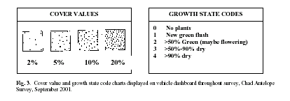
RECORDS: Fig. 3. Cover value and growth state code charts displayed on vehicle dashboard throughout survey, Chad Antelope Survey, September 2001.
RECOMMENDATION: WILDLIFE
RECORDING: However,
in the rolling dune habitats of the Manga the combination of landscape form and
the need to stop
and search for rarities such as dama gazelles led to an uneven pattern of dorcas
gazelle sighting/recording.
For these reasons density estimates are only very approximate. RECOMMENDATIONS: 1. In future reconnaissance surveys more systematic use of range-finder equipment would improve reliability of density estimation for both wildlife and livestock. 2. The methodology used during the current reconnaissance has identified regions, particularly the central grasslands of the Wadi Rimé-Wadi Achim Faunal Reserve, where censuses that employ transect design integrated with formal distance sampling would be useful for obtaining accurate wildlife density estimates.
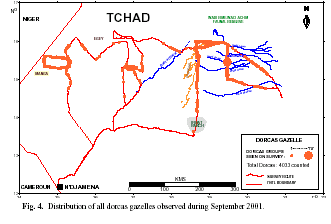
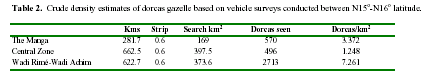
RESULTS DORCAS GAZELLE Dorcas gazelles were encountered regularly over long sections of the survey (Fig. 4). A total of 4,033 animals were recorded, making them the most abundant of the wild large mammal fauna. DISTRIBUTION: Dorcas gazelles were widely distributed throughout the central zone of the survey, with some of the highest densities observed in the central grasslands of the Wadi Rimé-Wadi Achim. Overall, nearly 94% of recorded animals were seen between N15o-N16o. latitude. A crude estimate comparing relative dorcas gazelle density within these latitudes in The Manga, the central zone due north of the Bahr al Gazal, and the Wadi Rimé-Wadi Achim Faunal Reserve is given Table 2. Our crude density estimate assumes that all gazelles were seen (in fact they were likely to be under-recorded) within a strip width of 300 m (an approximation derived using a rangefinder) either side of the vehicles, and that this was consistent in all habitats (in fact, visibility varied with terrain and vegetation type). For example, visibility was best in open habitats such as the Wadi Rimé-Wadi Achim, whereas denser vegetation and rolling dunes limited visibility in the Manga. Because the primary search target in the Manga was the dama gazelle, this may have lead to an underestimation of dorcas gazelles for this segment of the survey. Overall, it is most likely that dorcas gazelle densities were underestimated.
Despite these caveats the crude density estimates mapped by geographic location provided information on the present status of dorcas gazelles over a very extensive area of central Chad. These data confirmed that the species is continuously distributed over a very large area and implies that both the Chadian Manga (c. 5000 km2) and the central grassland zone of Wadi Rimé-Wadi Achim (at least 20,000 km2) held very substantial numbers of dorcas gazelles in September 2001. HABITAT AND FEEDING: As for dama gazelles (see below) it was not possible to make systematic observation of dorcas gazelle feeding patterns. The species was widely distributed in most major habitat types of the central survey zone (Fig. 4), but not in the continuous long grass sward of the southern sector of the survey. A more detailed analysis of dorcas habitat use will be included in the final report. GROUP
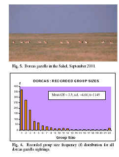
SIZE & COMPOSITION: A simple frequency
distribution of group sizes is presented in
Figure 6. The vehicle survey techniques did not
permit social-behavioral patterns to be evaluated,
and the disturbance induced by the vehicles
no doubt disrupted normal social units and
skewed group size observations (see fleeing gazelle,
Fig. 5). Singletons and twosomes were the
most frequently recorded group types, but most
gazelles seen appeared to be with two or three
others (mean group size, 3.5) and 87% of the entire
record was accounted for by group sizes up to
twenty. Larger assemblies than this were recorded
on a handful of occasions, but these generally
represented multiple unassociated animals
scattered across the field of view. Group composition
data were obtained where possible, but
the need to conduct operations from a moving vehicle
severely limited and biased data collection.
Only 19% (216/1145) of dorcas gazelles
were age-classified and sexed. This biased
subset of the observations (mean group size of
the subset was 2 gazelles) indicated an adult male:adult
female ratio of 0.47 with only 5.6% yearlings,
which suggested a 27% calving rate among
the females. Indications from the full data set
imply a much lower recruitment rate overall. However,
potentially significant biases on evaluation of recruitment for the whole data
set, especially calf
hiding behavior in the favored grassland habitats, have not been assessed. A
fuller treatment will be given
in the final report. MORTALIY: A total of 30 dorcas gazelle carcasses (mainly single skulls) were encountered through the survey. In the majority of instances the cause of death could not be determined because nearly all were in an advanced state of skeletonization. Twelve carcasses comprised a cache of bones found in the Manga, which were evidently the result of systematic, hunting and butchering. Of these 12 individuals, 7 were male 5 were female, and three individuals appeared to be juveniles (1-2 years of age). The age and sex distribution, and discarded horns, suggested that these animals had been hunted for meat. The observation that 40% of discovered dorcas gazelle mortality could be attributed to hunting is thought provoking. However, it would be inappropriate to cite this figure as a general measure of hunting mortality in the survey region because sampling was not systematic, a high proportion of skeletons were concentrated at a single site, and the cause of death could not be determined in most instances. GENETICS STUDIES: Dorcas gazelle carcasses discovered on the survey were used to recover skin samples, usually from dry facial skin adhering to parts of the skull. Dry samples (typically a 1cm x 1cm section of skin with or without hair) were placed in individual manila envelopes labelled with date, species, sex and location with a matching wet sample placed in a tube of strong saline/DMSO buffer. Material from 24 different dorcas gazelle from all parts of the survey area (including 12 from the hunting cache in the Manga) was recovered in this way and has been taken to the King Khalid Wildlife Research Centre laboratory in Saudi Arabia. These specimens will be combined with dorcas gazelle samples collected from other regions of North Africa to help define species taxonomy.
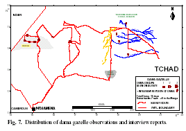
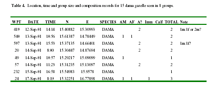
DAMA GAZELLE A total of 15 dama gazelle were encountered on eight occasions between the 12th and 17th September 2001. Long-range photographs were obtained showing some details of pelage coloration in eight of the individuals (Figs. 9-11). DISTRIBUTION: The distribution of dama gazelle observations and information obtained on the survey are shown in Figure 7. The survey established the presence of a dama gazelle population inhabiting the Manga area, and suggested that this population may range across the international border with Niger, where the Manga habitat is known to extend for an equivalent area. No dama gazelle were seen during the survey in Wadi Rimé-Wadi Achim, but the survey results suggested that small numbers may still be found there. The rate of positive response for dama gazelle during interviews was similar (9/15 interviews) in the eastern half of the survey to what it was in the Manga area (5/11 interviews). Interviewees mentioned Wadi Haddad, Wadis Kaleb and Ouale and Wadi Achim as areas where they had seen dama gazelles. Time constraints prevented exploration of the northwestern end of Wadi Achim; based on John Newby’s prior experience in the region, it is believed that dama gazelles may still inhabit this region.
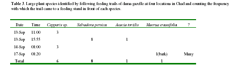
HABITAT AND FEEDING OBSERVATIONS: The survey results suggested an elongate east-west distribution of dama gazelles within a narrow band of latitude. Strong latitudinal stratification of habitat is a major feature of the Sahelian zone. Preliminary comparison of dama gazelle distribution with the distribution of tree cover and tree composition suggests an association with patches of marginally increased tree cover (5-10%) and possibly some level of association with the distribution of prominent Capparis sp. and more especially Salvadora persica. Observations of f ood plant selection by dama gazelles were extremely limited. On one occasion (the last observation at 08:20 am on 17th September) dama gazelles were observed feeding before they ran off, but they were spotted at a range of approximately 1 km through a spotting telescope and binoculars. No plant species could be identified. A few indirect observations of dama gazelle food selection were made by following tracks leading consecutively to feeding stands in front of larger plants. The frequency with which plant species was recorded along such feeding trails is summarized for the four occasions where this produced clear indications in Table 3 below. Table 3. Large plant species identified by following feeding trails of dama gazelle at four locations in Chad and counting the frequency with which the trail came to a feeding stand in front of each species.
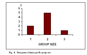
GROUP SIZE AND COMPOSITION: Group
size ranged from one to three individuals
(mode = 2, Fig. 8). Because
in all cases the animals were
shy and exhibited flight distances
in excess of 250 m, age and
particularly sex could not be determined
accurately (Table 4). Fig. 8. Histogram of dama gazelle group size.
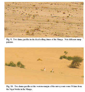
Fig. 9. Two dama gazelles in the fixed rolling dunes of the Manga. Note different rump patterns.
Fig. 10. Two dama gazelles at the western margin of the survey route some 30 kms from the Niger border in the Manga. APPEARANCE AND PELAGE PATTERN: In the field the clean solid red and white appearance of all the dama gazelles encountered was very striking. Pattern details and the extent of dark coloration are known to vary considerably in dama gazelle, with a presumed general tendency for the amount of red color to diminish from western Gazella dama mhorr to eastern Gazella dama ruficollis. Observations of pelage pattern in these indigenous Chadian animals are of special interest to help clarify the natural distribution of coat types. In all cases it appeared that the adult or near adult animals seen were white-faced. Red coloration extended over the neck with a white throat spot and a mainly solid red cape extending 2/3rds to 3/4ths of the way down the back. There was little indication of the cape fading along the back. In the first sighting it was noted that one animal exhibited a narrow white sinuous extension of red color across the haunch (distinct but not as broad as seen in Mhorr) while its companion showed a clean white haunch and rump.
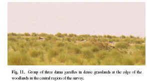
Fig. 11. Group of three dama gazelles in dense grasslands at the edge of the woodlands in the central region of the survey. Subsequent inspection of projected images of 8 different individuals in which details of rump pattern could be seen showed that the haunch stripe was present in six of the animals and apparently absent in two. Also the precise extent of the cape, and the angle with which it runs along the flank may show a small amount of variation between wild individuals. It is recommended that the captive breeding community be consulted to find out if age and sex related factors are known to influence differences in individual coat pattern, or whether this represents within population variation. GENETICS
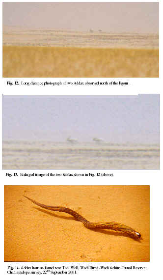
STUDIES USING WILD AND CAPTIVE DAMA: The EEZA animals are descendents of wild Gazella dama mhorr captured in the area of southern Morocco. The objective will be to extract mitochondrial DNA (mtDNA) sequences and publish a brief account of the comparative genetics of contemporary wild Chadian animals with captive stocks representing the extremes of the species’ range. DIRECT (PHOTOGRAPHIC) AND INDIRECT (HORNS) EVIDENCE OF ADDAX (Addax nasomaculatus) IN CHAD
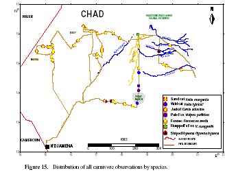
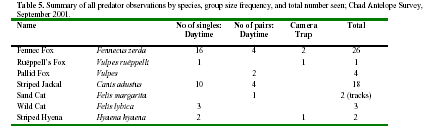
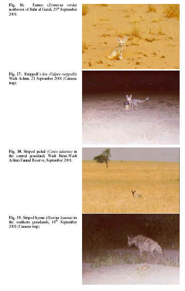
CARNIVORES In the course of the survey, all carnivore species encountered were recorded using the same methods as for antelopes. A total of 47 carnivore encounters are summarized in Table 5 (below), showing that fennec foxes (Fig. 16) were the most frequently encountered species followed by striped jackal (Fig. 18). Pallid fox (Fig. 17), African wild cat and hyena (Fig. 19) were seen on one to three occasions each while tracks of a pair of sand cats found north of Egeuï were notable for a long running chase, probably followed by mating before the animals apparently moved off in separate directions. A distribution map of predator observations (Fig. 15) confirms that fennec foxes were widespread in the open sandy plains north and west of the Bahr al Gaza. Pallid foxes and African wild cats were only recorded in the long grass plains to the southeast of the survey zone while striped jackals were seen in all habitats from southern grasslands to small patches of doum palm (Hyphaenae thebaica) isolated in sand dune formations of Egeuï.
Table 5. Summary of all predator observations by species, group size frequency, and total number seen; Chad Antelope Survey, September 2001.
The data in Table 5 incorporate observations from eleven nights of camera trapping (133.5 hours), usually using improvised baits, which produced images of fennec fox, Ruëppell’s fox (Fig. 17) and striped hyena (Fig. 19).
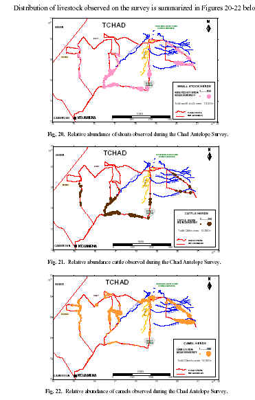
DISTRIBUTION AND ABUNDANCE OF LIVESTOCK IN RELATION TO WILDLIFE Distribution of livestock observed on the survey is summarized in Figures 20-22 below.
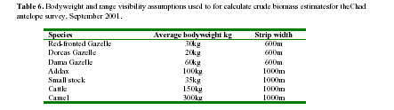
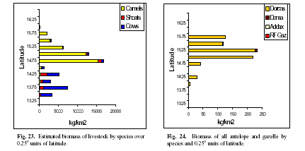
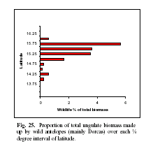
A crude estimate of ungulate biomass per square kilometer was calculated using assumptions summarized in Table 6, taking into account track length (estimated using GPS data) for each quarter degree unit of latitude. Wildlife and livestock biomass distributions were compared by grouping over the primary north south habitat gradient in Figures 23, 24 and 25 below. Table 6. Bodyweight and range visibility assumptions used to for calculate crude biomass estimatesfor theChad antelope survey, September 2001.
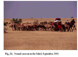
Since the food resources of the Sahel/desert edge are exploited by both man and wildlife on a seasonal migratory basis, the recorded distributions represented only a snapshot of the general location of large ungulates found in September 2001. Large numbers of livestock were in the process of migrating to new areas (mainly but not exclusively moving southward) during this survey, Fig.26). Nevertheless there was value in comparing the relative magnitude and relative location of livestock and wildlife. Despite the movement, these data (Fig. 23) suggested a clear geographic division (around N14o 30’) between the cattle-keeping economies of the south and the camel nomads of the north. Maximum wildlife biomass values were observed marginally to the north of the highest camel density zones in the vicinity N15o 0’ to N15o 25’ (Fig. 25). The most striking feature of the comparison between wildlife and livestock densities is the great preponderance of livestock. Overall the wildlife component comprised only 1.23% of the total recorded ungulate biomass (3.7% in metabolic equivalent kg 0.75) locally reaching a maximum of nearly 5.6% only where overall numbers were relatively reduced at latitude N15o 45’ (Fig. 25). SUMMARY In the twenty-two days spent in the field we covered around 3,500 km, mostly in the regions of Kanem, Bahr Al-Ghazal, Batha and Biltine. At each administrative center we informed the authorities about the goals of our mission and asked them for information regarding the local wildlife and its status. Together with our own observations, we learned a great deal about the conservation status of wildlife of the Sahel.
In spite of the good rainy season and generally abundant pasture, we were disappointed to find that the larger members of the Chad's aridland fauna have virtually disappeared, and this since many years (the 1960s west of the Bahr Al-Ghazal, and the 1970s and 1980s to the east). Although the smaller species, such as the dorcas gazelle, the bustards and small carnivores seem to be benefiting from the new grazing, and from insects and rodents, the oryx and the Saharan population of the ostrich have totally disappeared. As for the addax and the dama gazelle, both are now very rare and threatened with extinction in the coming years unless measures to ensure their protection are not adopted immediately. During our trip we were fortunate enough to see two addax and some fifteen dama gazelles, all in areas marginal for their survival. Although wildlife has paid dearly in the past from successive droughts and the political instability of the 1970s and 1980s, hunting and encroachment of critical habitats continue to weigh heavily on it. Everywhere we went we saw signs of recent hunting – abandoned trophies, vehicle tracks, spent cartridges, eyewitness reports, etc. While some of this hunting is certainly carried out by local herders and traditional hunters (blacksmiths for the most part), the most frequent and most deadly for the threatened species is that carried out by people with access to all-terrain vehicles, such as the military, well-diggers, merchants, administrators, and others. If the problem of motorized hunting can logically be addressed more easily than that posed by the rural population, whatever the method chosen the application of rules and regulations will require an important investment in the services responsible for wildlife protection. On the basis of our observations, and pending the adoption of a more global, long-term strategy, we have the following short to medium-term recommendations: 1. There is an urgent need for the highest government authorities to reaffirm the importance of wildlife and its protection. A healthy wildlife resource plays an important role not only as a fundamental part of the national heritage but also as an essential element for the maintenance of natural ecosystems and the fight against desertification. If well managed, wildlife can also become a non-negligible, complementary economic resource. 2. A special campaign, targeted specifically at the civil authorities and the armed forces, is required to ensure their full compliance with the legislation relevant to hunting and nature protection. The merchants, and especially the well diggers, that frequent wildlife areas are also important targets for this type of approach. In our opinion, two regions are especially sensitive: i) the route Calla Id-Todi-Kouba Olanga; and ii) the Manga. Regarding well-digging activities, and other infrastructure development projects in sensitive zones, it is essential that these be preceded by environmental impact assessments to gage their effects on the local fauna and flora. While it is clear that herders need wells, it is also well known that a badly placed well can in the long-term provoke more problems than it resolves (soil erosion, desertification, over-grazing, wildlife extinction, etc.). 3. Capacity-building for wildlife protection, monitoring, and the management of protected areas. Knowing that Chad has many priorities in terms of its social and economic development, the rehabilitation and maintenance of an adequate infrastructure to look after wildlife and protected areas is also important. Pending the development of a comprehensive plan for the restoration of Chad’s protected areas, well-focused, smallscale investments could deliver immediate results. For example, the establishment of mobile monitoring and extension units, or increased support (manpower, transport, running costs) to the ranger stations in the Wadi Rimé-Wadi Achim reserve at Arada and Djedda. Although the reserve has suffered enormously from drought, civil war and the ravages of ‘tourist-hunters’, its role in the restoration of Chad’s aridland fauna and ecosystems remains primordial. 4. Even though substantial financial resources are required to tackle a serious situation, in the long-term successful wildlife and habitat conservation will also depend on the concerted efforts of civil society and especially those people that share the space and the natural resources with wildlife. In this context, it is essential to support the efforts of the non-governmental sector so that it can fully play its complementary role to that of the state. 5. Although our short-term objective was to assess the status of Chad’s aridland wildlife, the long-term goal is to assist the country in its efforts to conserve this same fauna and flora. With the data that we have collected we are all better equipped to engage both the national authorities and international partners so that a strategy can be developed, funded and made operational. We are convinced that increased contacts between Chad, the donor community, and specialized agencies will be fruitful. Apart from bilateral assistance, the important role international organs such as the Bonn Convention (CMS), UNESCO (World Heritage), the Global Environment Facility (GEF), and international NGOs, such as WWF and IUCN, can play should not be overlooked. Pending the production of the mission’s full report, we sincerely hope that these few conclusions will be useful to you.
REFERENCES 1. Beudels-Jamar, R.C., Devillers, P. and R.M. LaFontaine. 1999. Conservation Measures for Sahelo-Saharan Antelopes. Action plan and Status Reports. Revised and adopted at the workshop in Djerba, Tunisia 19-23 February 1998. CMS Technical Series Publication N°4. UNEP/CMS Bonn. 2. Beudels-Jamar, R.C. and P. Devillers. 1999. Proceedings of the Seminar on the conservation and restoration of Sahelo-Saharan Antelopes. Djerba, Tunisia 19-23 February 1998. CMS Technical Series Publication N°3. UNEP/CMS Bonn. 3. Newby, J. 1978. Scimitar-horned oryx – end of the line? Oryx 14:219-221. 4. Newby, J. 1980. Can addax and oryx be saved in the Sahel? Oryx 15:262-266. 5. Newby, J. 1981. Desert antelopes in retreat. WWF News, 14:3. 6. Newby, J.E. 1984. Large mammals. In Sahara Desert. J.L. Ed (Cloudsley-Thompson). Pergamon Press, Oxford. 7. Newby, J. 1988. Aridland wildlife in decline: the case of the Scimitar-horned oryx. Pp 146-166 In Conservation and biology of desert antelopes, Eds (A. Dixon and D. Jones). Christopher Helm, London. 238 pp. 8. Newby, J. 1998. Conserving Sahelo-Saharan Wildlife. AZA Antelope Taxon Advisory Group Meeting, Bamberger Ranch, TX. |